Difference between revisions of "Catchment"
From REFORM wiki
(Created page with "=Catchment= ==General description== ==Case studies where this River Characterisation is relevant== <Forecasterlink type="getProjectsForRt" code="2"/> ==Tools where this Riv...") |
|||
| (5 intermediate revisions by one other user not shown) | |||
| Line 1: | Line 1: | ||
=Catchment= | =Catchment= | ||
| − | |||
| − | == | + | ==Definition== |
| − | + | A catchment is an area of land that is drained by a river and its tributaries. | |
| − | + | ||
| − | + | ==Delineation criteria== | |
| − | == | + | Delineation can be made based on the topographic divide (watershed) using digital elevation models (DEM) and a Geographic Information System (GIS), or with an existing catchment boundary database. |
| + | |||
| + | ==Methods and Data sources== | ||
| + | * Digital elevation models (e.g. [http://epp.eurostat.ec.europa.eu/portal/page/portal/gisco_Geographical_information_maps/geodata/digital_elevation_model EU-DEM]) using GIS algorithms to delimit the divide | ||
| + | * EU-wide [http://ccm.jrc.ec.europa.eu/php/index.php?action=view&id=23 CCM2 River and Catchment Database (v2.1)] or [http://www.eea.europa.eu/data-and-maps/data/european-catchments-and-rivers-network EEA Ecrins] (connected watersheds, rivers, lakes, monitoring stations, dams) data set | ||
| + | |||
| + | <gallery> | ||
| + | File:Catchment3.jpg|The River Frome catchment is a medium-sized, lowland, calcareous catchment located in southern England. | ||
| + | </gallery> | ||
[[Category:River Characterisation]] [[Category:Catchment]] [[Category:Catchment]] | [[Category:River Characterisation]] [[Category:Catchment]] [[Category:Catchment]] | ||
Latest revision as of 16:34, 7 January 2019
Catchment
Definition
A catchment is an area of land that is drained by a river and its tributaries.
Delineation criteria
Delineation can be made based on the topographic divide (watershed) using digital elevation models (DEM) and a Geographic Information System (GIS), or with an existing catchment boundary database.
Methods and Data sources
- Digital elevation models (e.g. EU-DEM) using GIS algorithms to delimit the divide
- EU-wide CCM2 River and Catchment Database (v2.1) or EEA Ecrins (connected watersheds, rivers, lakes, monitoring stations, dams) data set
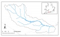
The River Frome catchment is a medium-sized, lowland, calcareous catchment located in southern England.
