Difference between revisions of "Landscape unit"
From REFORM wiki
(Created page with "=Landscape unit= ==General description== ==Case studies where this River Characterisation is relevant== <Forecasterlink type="getProjectsForRt" code="3"/> ==Tools where thi...") |
(→Landscape unit) |
||
| (3 intermediate revisions by the same user not shown) | |||
| Line 1: | Line 1: | ||
=Landscape unit= | =Landscape unit= | ||
| − | == | + | ==Definition== |
| + | Landscape units are portions of the catchment with similar morphological characteristics. | ||
| − | |||
| − | + | ==Delineation criteria== | |
| − | == | + | The catchment is divided into landscape units that are broadly consistent in terms of their topography, geology and land cover, as these factors determine the hydrological responsiveness of a catchment and the source and delivery of sediment to the river system. |
| − | |||
| − | |||
| − | + | ==Methods and data sources== | |
| + | GIS overlay of some of the following in the stated order of priority | ||
| + | # Digital Elevation Model (e.g. [http://epp.eurostat.ec.europa.eu/portal/page/portal/gisco_Geographical_information_maps/geodata/digital_elevation_model EU-GDEM]) | ||
| + | # Geological maps ([http://onegeology-europe.org One Geology Europe]) | ||
| + | # [http://www.eea.europa.eu/data-and-maps CORINE Land Cover] | ||
| + | # Supporting information from: Google Earth / Orthophotos | ||
| + | |||
| + | |||
| + | <gallery> | ||
| + | File:Landscapeunit3.jpg|The Frome catchment was delineated into 3 landscape units based on elevation, geology and land cover. | ||
| + | </gallery> | ||
| + | |||
| + | |||
| + | [[Category:River Characterisation]] [[Category:Landscape unit]] [[Category:Landscape unit]] | ||
Latest revision as of 13:22, 22 May 2014
Landscape unit
Definition
Landscape units are portions of the catchment with similar morphological characteristics.
Delineation criteria
The catchment is divided into landscape units that are broadly consistent in terms of their topography, geology and land cover, as these factors determine the hydrological responsiveness of a catchment and the source and delivery of sediment to the river system.
Methods and data sources
GIS overlay of some of the following in the stated order of priority
- Digital Elevation Model (e.g. EU-GDEM)
- Geological maps (One Geology Europe)
- CORINE Land Cover
- Supporting information from: Google Earth / Orthophotos
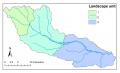
The Frome catchment was delineated into 3 landscape units based on elevation, geology and land cover.
