Reach
Reaches
Definition
Section of river along which boundary conditions are sufficiently uniform that the river maintains a near consistent internal set of process-form interactions. (A river segment can contain one to several reaches). As a general rule, the length of a reach should not be smaller than 20 times the mean channel width, although shorter reaches can be defined where local circumstances are particularly complex.
Delineation criteria
- Channel morphology (particularly planform)
- Floodplain features
- Artificial discontinuities that affect longitudinal continuity (e.g. dams, major weirs / check dams that disrupt water and sediment transfer)
- River confinement
The boundaries of river segments form the first delineation of river reaches. However, subdivision may be necessary, since the aim is to define reaches of similar channel and floodplain morphology, which are likely to reflect local changes in bed slope that were too small to demarcate a segment, and changes in sediment calibre, discharge and sediment supply associated with smaller tributary confluences or artificial discontinuities such as dams, major weirs / check dams that disrupt water and sediment transfer. Changes in river confinement as indicated by the ratio of channel width to alluvial plain width within a segment can also affect channel and floodplain characteristics and so a river confinement index (Rinaldi et al., 2012, 2013), defined as the ratio between the alluvial plain width (including the channel) and the channel width (or the reciprocal, defined as ‘entrenchment’, e.g. Polvi et al., 2010), can help in delineating reaches.
Methods and data sources
Automated methods are becoming increasingly available that delineate or aggregate homogenous reaches using topographic and other data (e.g. Alber and Piégay, 2011, Bizzi and Lerner, 2012, Notebaert and Piégay, 2013). The application of such automated procedures to a Spanish river is presented in Thematic Annex A. However, it may be necessary to refine the outputs of automated delineations for the present purposes or to base the entire delineation on a visual analysis of imagery and map data.
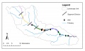
The River Frome is delineated into 15 reaches based on valley confinement, river planform and the presence of major weirs.
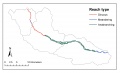
The River Frome has sinuous, meandering and anabranching reaches.

