Reach
Reaches
Definition
Section of river along which boundary conditions are sufficiently uniform that the river maintains a near consistent internal set of process-form interactions. (A river segment can contain one to several reaches). As a general rule, the length of a reach should not be smaller than 20 times the mean channel width, although shorter reaches can be defined where local circumstances are particularly complex.
Delineation criteria
- Channel morphology (particularly planform)
- Floodplain features
- Artificial discontinuities that affect longitudinal continuity (e.g. dams, major weirs / check dams that disrupt water and sediment transfer)
- River confinement
Methods and data sources
Segments are subdivided into reaches by visual interpretation of consistent river and floodplain (bio) geomorphic pattern using
- Google Earth
- Orthophotos
- Multi-spectral remotely-sensed data
- Lidar data
(Field reconnaissance can provide useful confirmation / additional data)
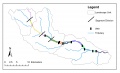
The River Frome is delineated into 15 reaches based on valley confinement, river planform and the presence of major weirs.
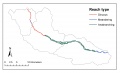
The River Frome has sinuous, meandering and anabranching reaches.

