File list
This special page shows all uploaded files.
| Date | Thumbnail | Size | User | Description | Versions | |
|---|---|---|---|---|---|---|
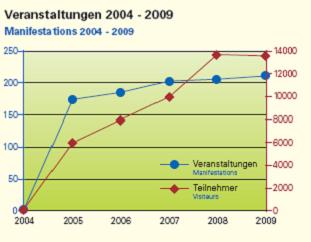
| 17:33, 18 July 2011 | Rheinauen Karlsruhe -Events.jpg (file) |  |
12 KB | Avarello | 1 | |
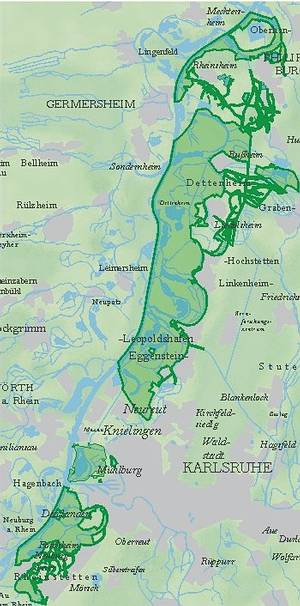
| 14:35, 18 July 2011 | Rheinauen Karlsruhe -Sites location.jpg (file) |  |
39 KB | Avarello | 1 | |
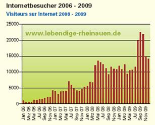
| 17:33, 18 July 2011 | Rheinauen Karlsruhe -Website.jpg (file) |  |
16 KB | Avarello | 1 | |
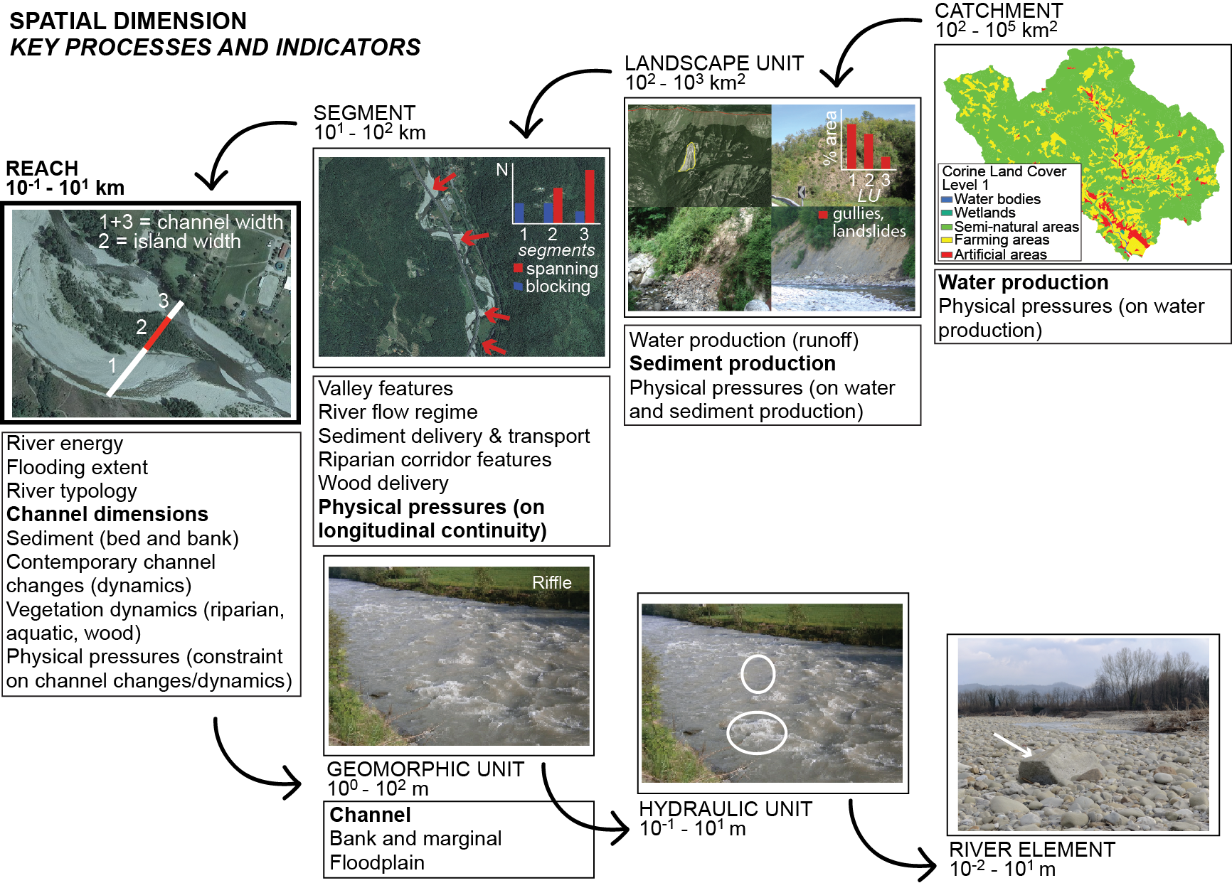
| 11:01, 3 June 2015 | RiverCharacterisation Figure1 last.png (file) |  |
1.61 MB | Bbelletti | 1 | |
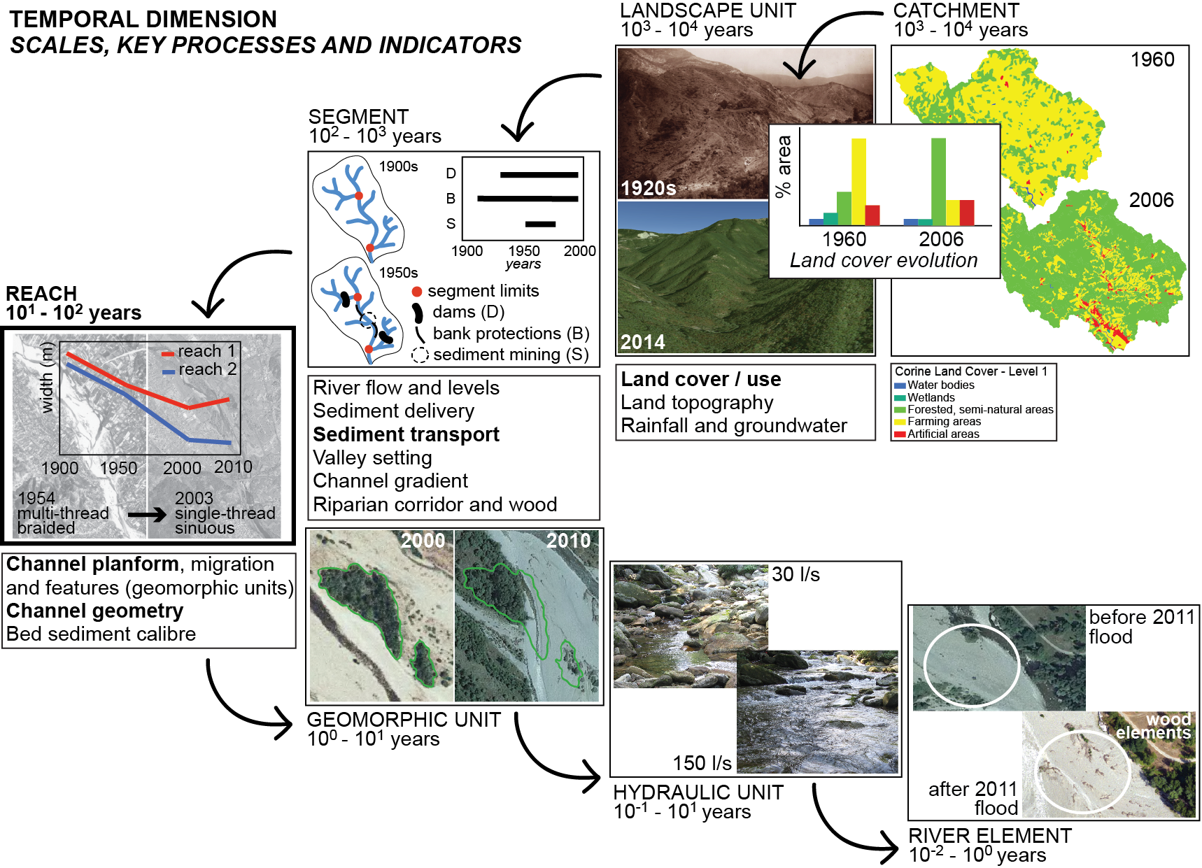
| 11:02, 3 June 2015 | RiverCharacterisation Figure2 last.png (file) |  |
1.41 MB | Bbelletti | 1 | |
| 11:03, 3 June 2015 | RiverCharacterisation Figure3 last.png (file) |  |
1.23 MB | Bbelletti | 1 | |
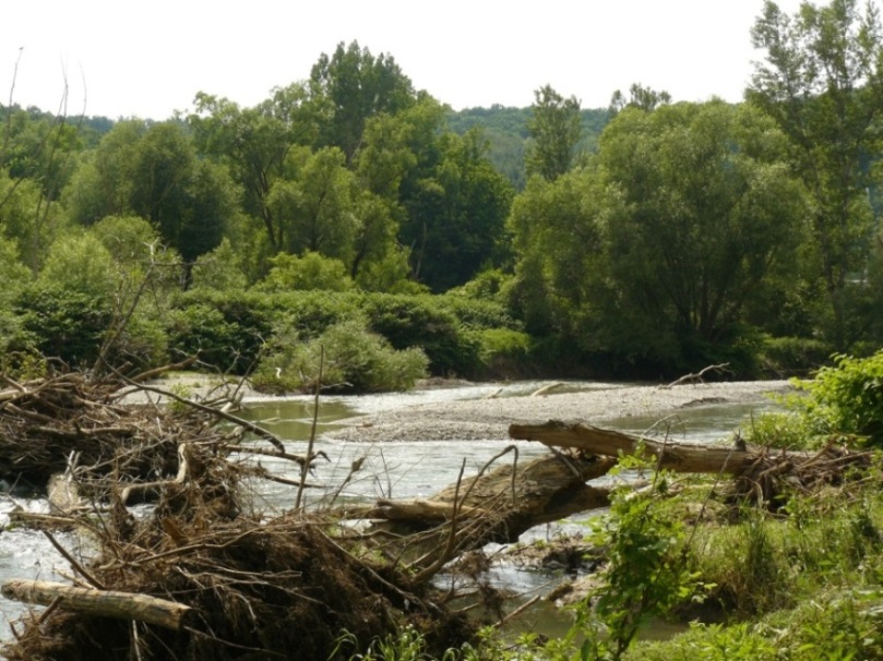
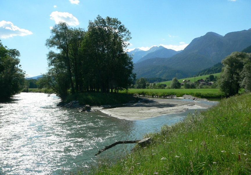
| 21:20, 8 December 2015 | River Pielach in Austria.jpg (file) |  |
0 B | Gertjan | 1 | |
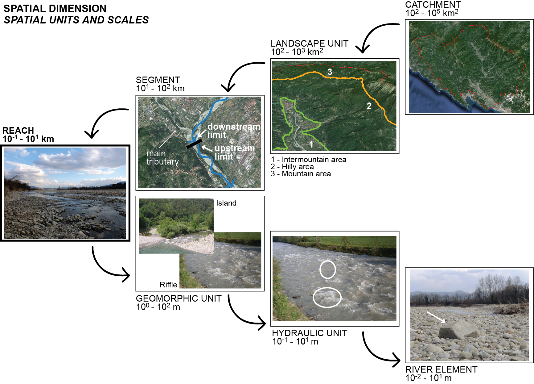
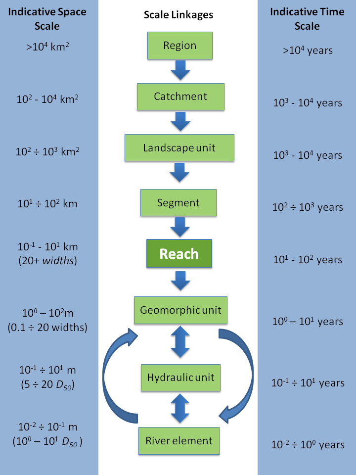
| 12:39, 9 January 2013 | River characterisation hierarchy of spatial scales.png (file) |  |
85 KB | Gjgeerling | Hierarchy of spatial scales for the European Framework, including indicative spatial dimensions and timescales over which these units are likely to persist. | 1 |
| 22:26, 14 April 2010 | River continuity.jpg (file) |  |
49 KB | Admin | Original source: http://www.fao.org/DOCREP/004/Y2785E/y2785e03.htm | 1 |
| 09:40, 1 September 2015 | River fragmentation.jpg (file) |  |
284 KB | Carlos alonso | 1 | |
| 13:49, 24 March 2010 | Romania typology.pdf (file) | 2.73 MB | Admin | 1 | ||
| 21:59, 6 August 2013 | Rosenheim before after.JPG (file) |  |
74 KB | Saskia.deltares | Rosenheim before and after the construction of the measures. Modified from Life vein – Upper Drau River (2011) | 1 |
| 15:41, 28 May 2014 | Ruhr 1.JPG (file) |  |
3.9 MB | Benjamin Kupilas | 1 | |
| 18:45, 19 May 2010 | Río anzur.pdf (file) | 702 KB | Dgjalon | 1 | ||
| 17:33, 8 June 2009 | S1 4 Arenillas Girola.pdf (file) | 2.86 MB | Morales | 1 | ||
| 10:28, 19 July 2011 | SDF-Public participation.jpg (file) |  |
28 KB | Avarello | 1 | |
| 13:18, 9 April 2009 | SDOC1181.pdf (file) | 115 KB | Admin | test pdf Deltares forecaster | 1 | |
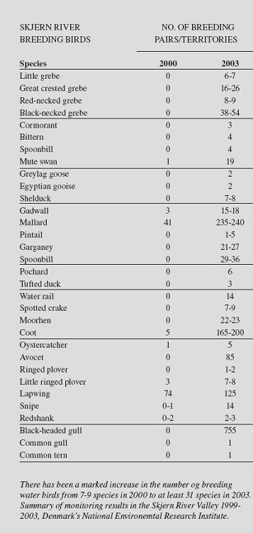
| 15:08, 8 July 2011 | SKJERN-Breeding birds evolution between 2000 and 2003.jpg (file) |  |
38 KB | Avarello | 1 | |
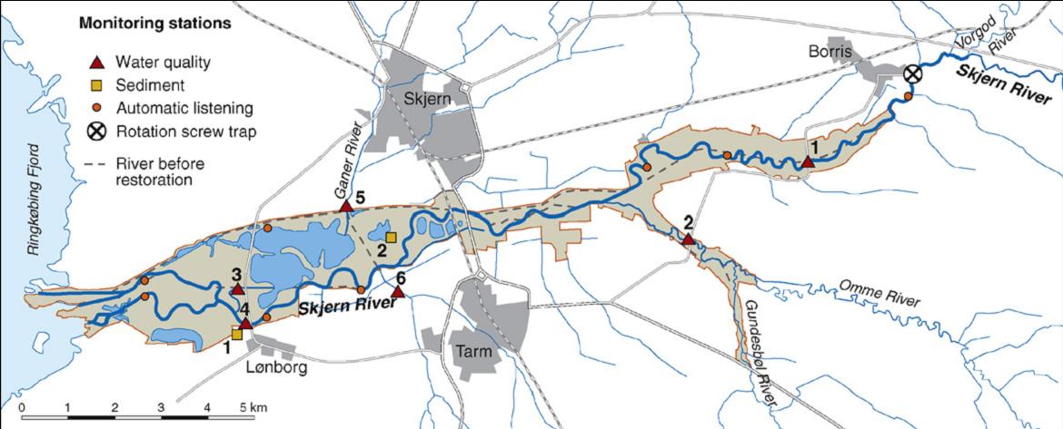
| 17:08, 8 July 2011 | SKJERN-River monitoring stations for water quality and transport of water and nutrients.jpg (file) |  |
79 KB | Avarello | 1 | |
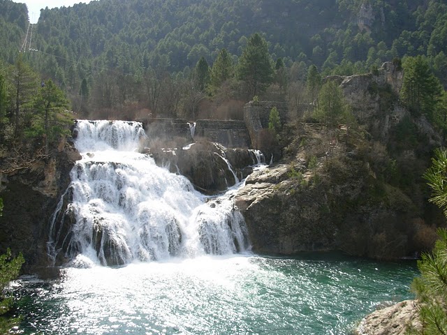
| 19:44, 20 April 2010 | Saltodelapoveda.jpg (file) |  |
98 KB | Dgjalon | Salto de la Poveda | 1 |
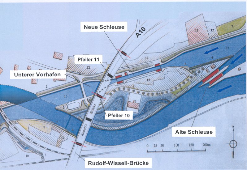
| 18:52, 7 April 2010 | SchleuseCharlottenburg drawing1.jpg (file) |  |
101 KB | CWolter | 1 | |
| 15:44, 27 April 2009 | Schleussecharlottenburg drawing1.jpg (file) |  |
101 KB | Admin | Plan of the site | 1 |
| 16:13, 14 November 2013 | ScottishMImAS.pdf (file) | 63 KB | Bbelletti | 1 | ||
| 15:20, 23 November 2010 | SedimentTransDis.jpg (file) |  |
43 KB | IGBBerlin | 1 | |
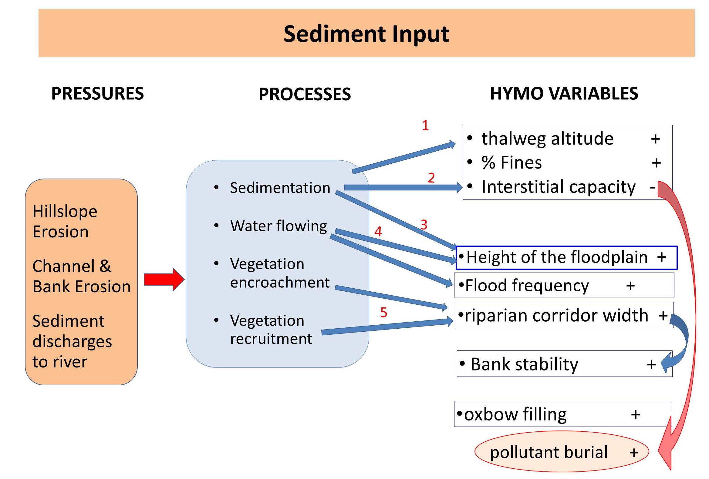
| 10:40, 1 September 2015 | Sediment input.jpg (file) |  |
245 KB | Carlos alonso | 1 | |
| 18:20, 19 March 2013 | Sediment transfer scheme small.png (file) |  |
33 KB | Michael | 1 | |
| 22:04, 8 December 2015 | Setting back the embankement River Enns.jpg (file) |  |
220 KB | Gertjan | 1 | |
| 08:44, 15 June 2010 | Simon Rinaldi 2006.jpg (file) |  |
77 KB | Otal | 1 | |
| 09:38, 16 April 2010 | Simons 2001.pdf (file) | 32 KB | Sven Teurlincx | The first page of a scientific article describing two case studies of side channel construction along the river Rhine. | 2 | |
| 15:47, 10 June 2015 | Skern RestoredSection.jpg (file) |  |
27 KB | Jochem | 1 | |
| 23:09, 13 April 2010 | Skerne brochure.pdf (file) | 546 KB | Gertjan | A pdf of the Skerne restoration project brochure | 1 | |
| 13:50, 30 July 2013 | Skerne map.JPG (file) |  |
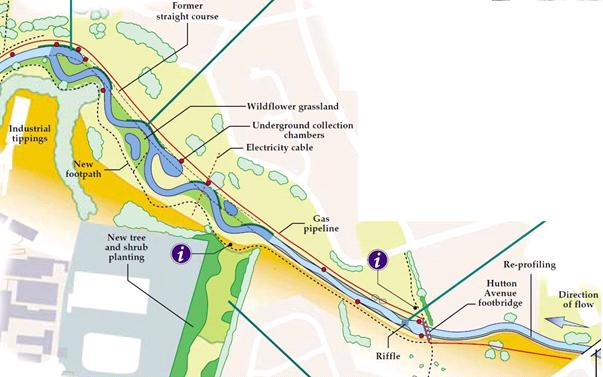
38 KB | Saskia.deltares | Map of measures Skerne | 1 |
| 23:16, 13 April 2010 | Skerne photos.pdf (file) | 120 KB | Gertjan | 1 | ||
| 20:24, 5 February 2013 | SlovakHAP.pdf (file) | 71 KB | Bbelletti | 1 | ||
| 20:24, 5 February 2013 | SlovenianSIHM.pdf (file) | 51 KB | Bbelletti | 1 | ||
| 14:20, 24 March 2010 | Spain typology.pdf (file) | 3 KB | Admin | 1 | ||
| 20:24, 5 February 2013 | SpanishIHF.pdf (file) | 51 KB | Bbelletti | 1 | ||
| 20:24, 5 February 2013 | SpanishQBR.pdf (file) | 55 KB | Bbelletti | 1 | ||
| 17:28, 29 January 2014 | Spree 1.jpg (file) |  |
10 KB | Benjamin Kupilas | Reconnected meander Mönchwinkel II: The former main channel was blocked by a gravel dam (left side at the picture) to redirect all flow through the new meander; the remaining old main stem stretch serves as new flow protected habitat. | 1 |
| 17:34, 29 January 2014 | Spree 2.jpg (file) |  |
11 KB | Benjamin Kupilas | Reconnected meander Mönchwinkel I (left meander) and Mönchwinkel II (right meander). | 1 |
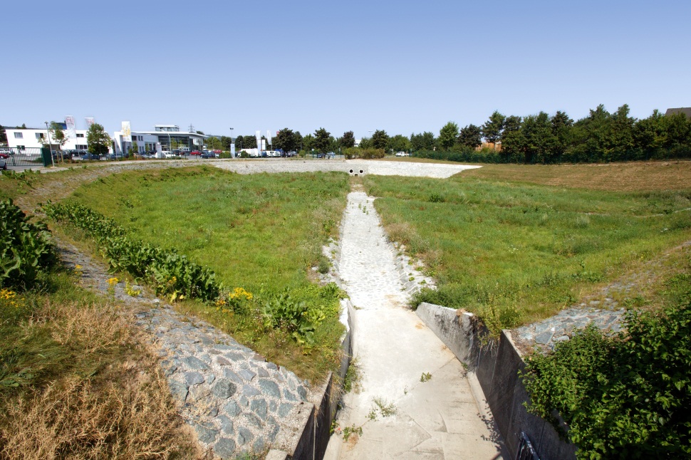
| 17:20, 4 December 2015 | Stormwater retention basin.jpg (file) |  |
278 KB | Gertjan | 1 | |
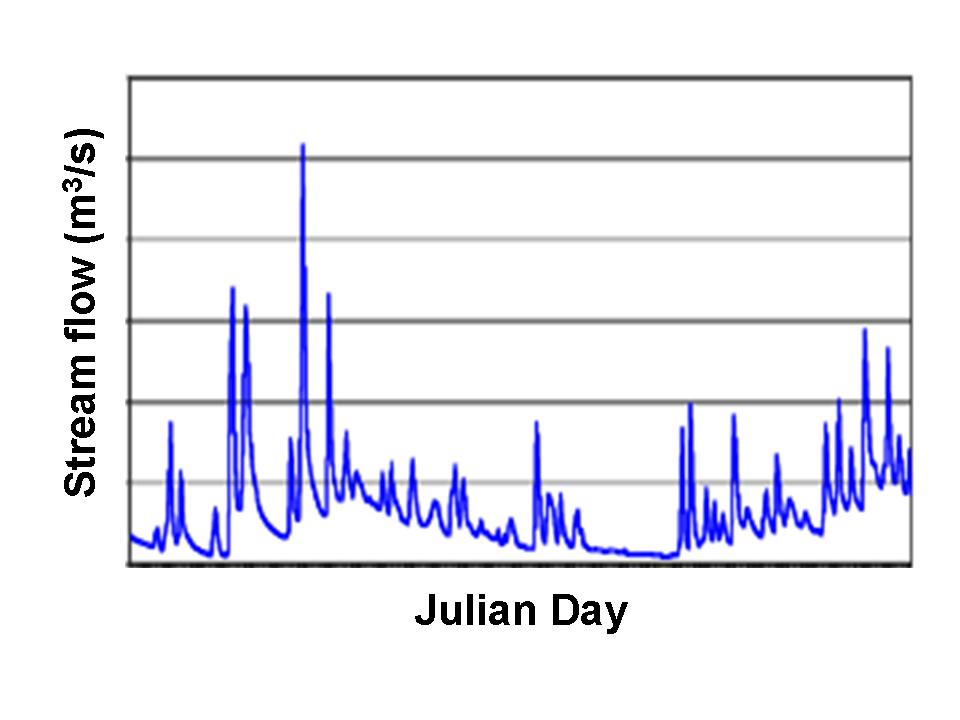
| 15:24, 28 April 2010 | Stream hydrograph.gif (file) |  |
12 KB | Admin | Original source: http://en.wikipedia.org/wiki/File:Stream_hydrograph.gif | 1 |
| 15:35, 28 April 2010 | Stream hydrograph wikipedia.jpeg (file) |  |
48 KB | Admin | Original source: http://en.wikipedia.org/wiki/File:Stream_hydrograph.gif | 1 |
| 18:35, 7 April 2010 | StuALippstadt 2002 Lippe Klostermersch.pdf (file) | 1.2 MB | IGBBerlin | 1 | ||
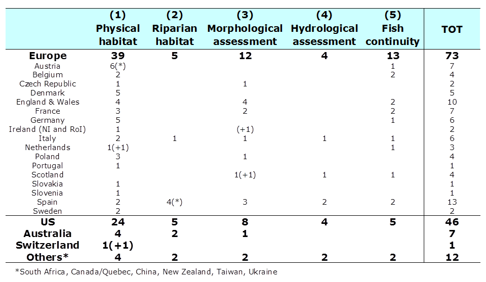
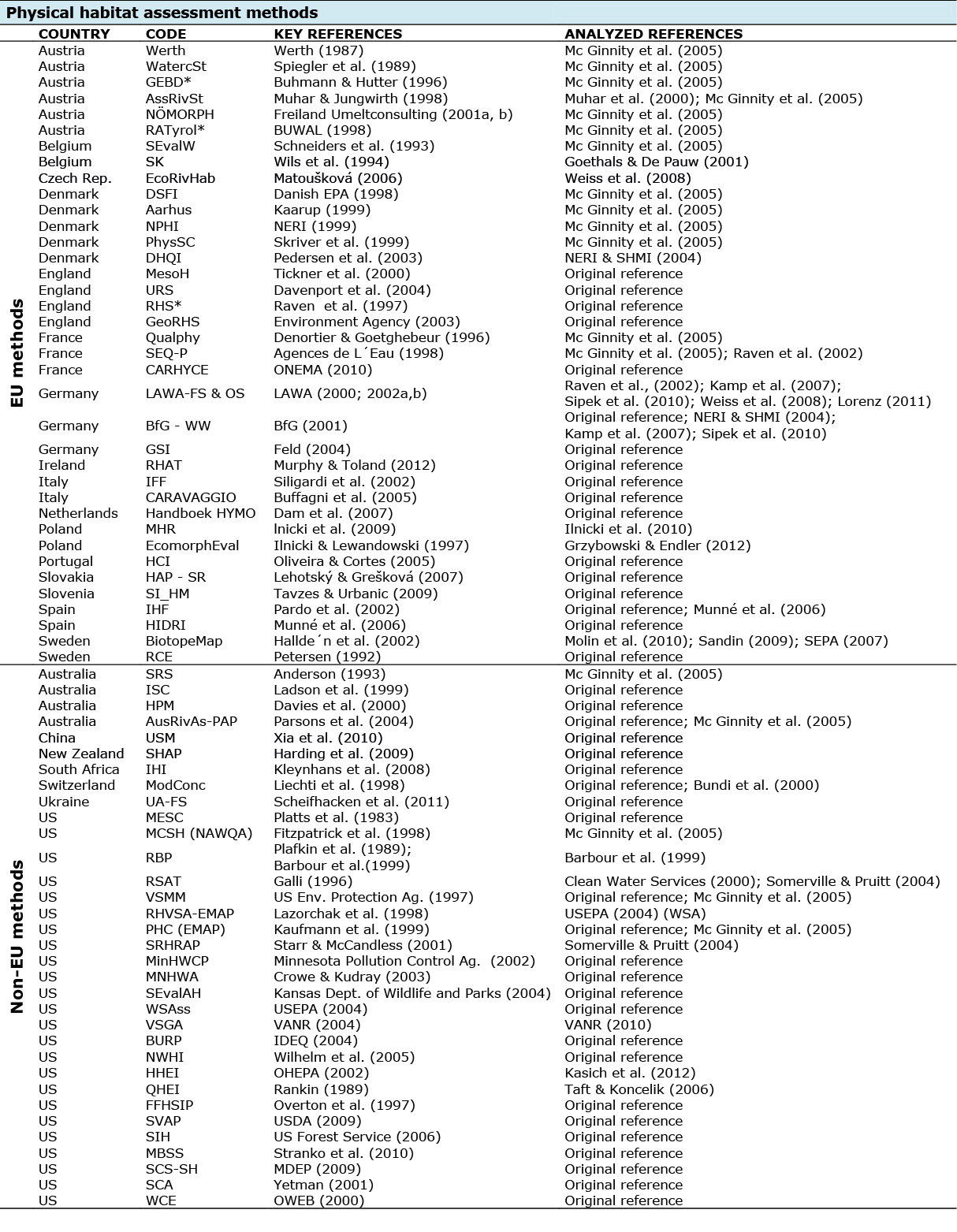
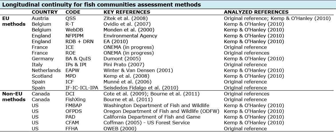
| 14:33, 31 January 2013 | TableMethodsReviewed clip.png (file) |  |
34 KB | Bbelletti | 1 | |
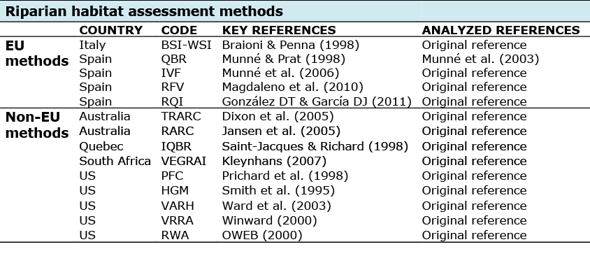
| 18:00, 8 February 2013 | TableRef1.png (file) |  |
247 KB | Bbelletti | 1 | |
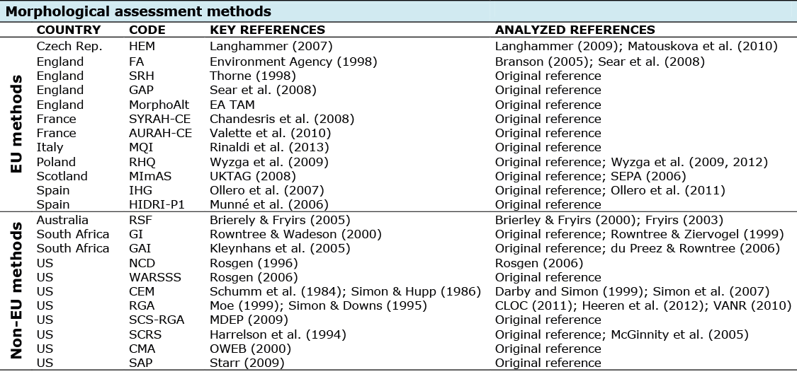
| 18:25, 8 February 2013 | TableRef2.png (file) |  |
49 KB | Bbelletti | 1 | |
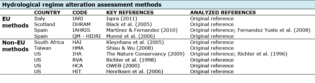
| 19:13, 8 February 2013 | TableRef3 .png (file) |  |
86 KB | Bbelletti | 1 | |
| 18:25, 8 February 2013 | TableRef4.png (file) | 41 KB | Bbelletti | 1 | ||
| 18:26, 8 February 2013 | TableRef5.png (file) |  |
76 KB | Bbelletti | 1 |
First page |
 Previous page |
 Next page |
Last page |