Category:River Characterisation
Contents
River Characterization: Multi-scale Hierarchical Framework
Background
River characterisation is a process to determine the hydromorphological condition of a river. It investigates the current form and behaviour or a river, and how these have changed over time.
Rivers naturally adjust over time, but human interventions in the channel, floodplain and wider landscape have dramatically altered their form and behaviour. Rivers have been straightened and deepened for navigation, dammed for milling and water supplies, and embanked for flood protection; floodplain have been converted to agriculture and are now home to millions of people; and in the wider landscape forests have been cleared, marshes drained and sediment sources blocked. These transitions have been ongoing for hundreds to thousands of years in Europe, and consequently few, if any, pristine rivers remain.
Interventions that have occurred upstream, downstream or within the reach can influence its hydromorphology form and behaviour. For example, siltation in a lowland river reach can be caused by upstream changes in land use that increase the delivery of sediment to the channel (e.g. intensification of arable agiculture), impoundments downstream that produce a backwater effect that induces sediment deposition (e.g. dams and weirs), or modifications to the channel form or dimensions that reduce its capacity to transport sediment (e.g. channel deeping and widening). In addition, hydromophology responds in a delayed way to processes and interventions within the catchment. As a result, understanding hydromorphology at the reach scale requires an understanding of current and past processes and interventions at larger spatial scales. Without such a multi-scale understanding, management strategies are not fully informed and may not provide sustainable solutions.
Link to ecology and river restoration
A multi-scale approach to investigating hydromorphology inevitably focuses on geomorphological characteristics and the hydrological and geomorphological processes that influence those characteristics across time and space, but these are crucial for river ecology. Hydromorphological processes drive longitudinal and lateral connectivity within river networks and corridors, the assemblage and turnover of habitats, and the sedimentary and vegetation structures associated with those habitats. All of these processes and structures are relevant to the provision of habitats to support the entire life cycle of organisms including refugia, feeding, spawning etc. As a result, a process-based, multi-scale understanding of hydromorphology is essential for identifying degraded segments and reaches of river and for developing sustainable restoration approaches that are in sympathy with hydromorphological functioning from catchment to reach scales.
The Framework
The multi-scale hierarchical framework has been developed to be a flexible, open-ended approach to hydromorphological assessment that is in line with the Water Framework Directive. As a result, the framework is compatible with WFD, but being process-based and multi-scale it allows practitioners to delve into further detail on the underlying drivers of hydromorphology. For more information on the links to WFD see Hierarchical Framework and WFD.
The framework leads practitioners through a series of steps to delineate their river into spatial units; characterise the relevant hydrological, geomorphological and ecological charactersitics at each scale; and assess the current hydromorphological condition of the river and its sensitivity to change. It aims to make best use of currently available surveys (physical habitat, riparian habitat, morphological, hydrological regime and fish continuity, etc) and readily-available (mainly free) Pan-European data sets to guide users on:
- What information is required at which spatial scale in the context of the data sets that are available and any new data that may be needed.
- How the above information can be collected or generated, and how it can be analysed, in order to:
- Describe and, crucially, explain variation in river character and behaviour within a catchment.
- Provide users with a basis upon which they are able to understand past and present behaviour and predict how a particular reach might react to changes (e.g. removal of local engineering modifications, flow regime naturalisation, reinstatement of longitudinal sediment connectivity).
- Allow users to define potential, site-specific, “reference” conditions against which current hydromorphological and ecological condition could be assessed.
Rules of Engagement
Some ‘rules of engagement’ need to be born in mind before embarking on the application of the methodologies proposed in this framework:
- Involve a professional geomorphologist
- Carry out a field survey
- View the framework as a guide to an approach rather than a recipe book
- Accept that true reference reaches devoid of human influence do not exist, and instead,
- Focus on hydromorphological processes.
Hierarchy of spatial units
The hierarchy of spatial units within which relevant properties, forms and processes can be investigated to understand and assess hydromorphology and its potential impact on ecology is presented in Figure 1. The units are arranged in decreasing over of size (indicative spatial scale) and persistence (indicative time scale): region, catchment, landscape unit, segment, reach and units. The reach is the key spatial scale at which the mosaic of features found within river channels and floodplains (i) responds to the cascade of influences from larger spatial scales and (ii) is influenced by interactions and feedbacks between geomorphic and hydraulic units and smaller elements such as plants, large wood and sediment particles within the reach.
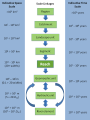
Figure 1. Hierarchy of spatial scales for the European Framework, including indicative spatial dimensions and timescales over which these units are likely to persist.
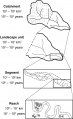
Figure 2: Delineation of spatial units


Three stages of river characterization
Stage 1: Delineation of spatial units
General Guidance
For catchment assessment and management purposes, the aim should be to subdivide the entire catchment into a complete set of units at all spatial scales from catchment to reach. In large catchments, this may not be possible, but it is necessary to subdivide the catchment to the scale of its major landscape units, after which representative subcatchments within each landscape unit can be analysed, delineating segments and reaches along the main channel and major tributaries for detailed analysis.
For assessment of a particular reach or segment, a minimum assessment needs to focus on the specific reach or segment and larger spatial units that contain and are immediately upstream of the reach or segment under consideration
Delineating the spatial units
The following links provide summaries and detailed information on the delineation of units at each spatial scale
Region: Summary - Detailed guidance
Catchment: Summary - Detailed guidance
Landscape unit: Summary - Detailed guidance
Segment: Summary - Detailed guidance
Reach: Summary - Detailed guidance
Units: Geomorphic untis, hydraulic uinits and river elements do not require ‘delineation’ at this stage of the analysis, but in later analytical stages we emphasise the identification of geomorphic units as key characteristics of river reaches.
Table 4.2 provides more information on the pan-European data sources referred to in the preceding links.
Stage 2: Characterisation of spatial units
Characterisation of spatial units at the different scales attempts to draw together readily-available information, surveys and data sets in ways that will promote understanding of the units and the linkages between them. Recommendations for characterisation take account of WFD requirements and make best use of existing pan-European and National data sets, including the outputs from physical habitat, riparian habitat, morphological, hydrological regime and fish continuity assessments, where they are available. Essential components of the characterisation are stressed.
Characterisation is divided into two steps: (1) the assessment of current condition and (2) the assessment of temporal change and quantification of rates of processes
Characterising current condition
The links below provide information on the aims of characterisation; data layers and hydromorphologically relevant parameters; potential data sources; and characteristics for each spatial unit.
Characterising past condition and quantifying rates of processes
The charactersiation process can be extended back in time to provide information on what the channel, floodplain and catchment looked like in the past; how and why they changed; and the rates of key hydromorphological processes. This provides managers with information on the underlying causes of hydromorphological degradation in a reach, the constraints on current and future management and restoration, and the likely evolutionary trajectories for the reach under different management scenarios.

Details on recommended data sources and analytical method for charactersitics at each spatial scale are available in chapter 6 of REFORM Deliverable 2.1
Stage 3: Indicators
The information assembled during the characterisation phases supports a short list of indicators of the current and past condition of a catchment and its spatial units. These key indicators provide an overview of current and past functioning of the catchment and its spatial units. Examples of the evaluation of indicators are provided in the volume of Annexes to this report describing Catchment Case study Applications.
Although the reach scale is often the main focus of interest, indicators representative of other spatial scales, particularly of the segment and landscape units in which the reaches are situated, provide important contextual information for interpreting reach scale indicators. Multi-scale indicators can provide much management-relevant information including:
- Assessing current reach condition and degree of alteration
- Understanding associations between landscape unit, segment and reach properties. In other words, what types of naturally functioning reach are sustainable and feasible within particular segment and landscape unit conditions and how do degraded conditions at the reach scale reflect processes or factors operating at the segment or landscape unit scales?
- Assessing potential reach condition in the context of its segment and landscape unit setting. In other words, to what extent and in what ways is the reach altered from the naturally-functioning reach types that are feasible in the segment and landscape unit setting, and to what extent does the condition of a reach conform to or differ from the condition of the segment in which it is situated?
- Establishing the spatial structure and condition of the river network. In other words, analyse the distribution of reaches of different style and condition throughout the network to assess (a) the presence and spacing of reaches that are in good condition, and (b) the degree of alteration of intervening reaches.
These types of information can feed into:
- Identification of the best condition reaches so that they may be protected.
- Selection of the most effective locations for restoration and the balance of expenditure on better condition reaches and linking reaches (according to both hydromorphological and ecological criteria).
- Selection of appropriate styles of restoration for the segment and landscape unit context of reaches.
More details on indicators of pas and present condition can be found in Chapter 8 of the REFORM Deliverable 2.1.
One of the reach-scale indicators is river type. An extended river typology with 22 river types is proposed that is based on river confinement, planform style, and riverbed sediment size. Details of the typology can be found in Chapter 7 of the REFORM Deliverable 2.1, along with typologies for floodplains and groundwater:surface water interactions.
More details on interpreting condition and trajectories of change can be found in Chapter 9 of the REFORM Deliverable 2.1.
Pages in category "River Characterisation"
The following 11 pages are in this category, out of 11 total.