Difference between revisions of "Segment"
From REFORM wiki
(Created page with "=Segment= ==General description== ==Case studies where this River Characterisation is relevant== <Forecasterlink type="getProjectsForRt" code="4"/> ==Tools where this River...") |
(→Segment) |
||
| (5 intermediate revisions by the same user not shown) | |||
| Line 1: | Line 1: | ||
=Segment= | =Segment= | ||
| − | == | + | ==Definition== |
| + | |||
| + | Section of river subject to similar valley-scale influences and energy conditions. | ||
| + | |||
| + | |||
| + | == Delineation criteria == | ||
| + | |||
| + | * Major changes in valley gradient | ||
| + | * Major tributary confluences (significantly increasing upstream catchment area, river discharge) | ||
| + | * Valley confinement (confined, partly-confined, unconfined) | ||
| + | * In mountainous areas, very large lateral sediment inputs | ||
| + | |||
| + | |||
| + | == Methods and data sources == | ||
| + | # Major segments are identified by applying GIS tools to a DEM with river network overlay, to define downstream breaks in valley gradient (and width) and in upstream contributing area. | ||
| + | # Major segments may be subdivided according to valley confinement interpreted from DEMs | ||
| + | # Google Earth images | ||
| + | # Orthophotos | ||
| + | |||
| + | |||
| + | <gallery> | ||
| + | File:Frome_segment_deline.jpg|The River Frome is delineated into 6 segments based primarily on major tributary confluences. | ||
| + | </gallery> | ||
| − | |||
| − | |||
| − | |||
| − | |||
| − | |||
[[Category:River Characterisation]] [[Category:Segment]] [[Category:Segment]] | [[Category:River Characterisation]] [[Category:Segment]] [[Category:Segment]] | ||
Latest revision as of 12:58, 22 May 2014
Segment
Definition
Section of river subject to similar valley-scale influences and energy conditions.
Delineation criteria
- Major changes in valley gradient
- Major tributary confluences (significantly increasing upstream catchment area, river discharge)
- Valley confinement (confined, partly-confined, unconfined)
- In mountainous areas, very large lateral sediment inputs
Methods and data sources
- Major segments are identified by applying GIS tools to a DEM with river network overlay, to define downstream breaks in valley gradient (and width) and in upstream contributing area.
- Major segments may be subdivided according to valley confinement interpreted from DEMs
- Google Earth images
- Orthophotos
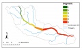
The River Frome is delineated into 6 segments based primarily on major tributary confluences.
