Category:River Characterisation
Contents
River Characterisation: Multi-scale Hierarchical Framework
The framework aims to make best use of currently available (physical habitat, riparian habitat, morphological, hydrological regime and fish continuity etc) surveys and readily-available (mainly free) Pan-European data sets to guide users on:
- What information is required at which spatial scale in the context of the data sets that are available and any new data that may be needed.
- How the above information can be collected or generated, and how it can be analysed, in order to:
- Describe and, crucially, explain variation in river character and behaviour within a catchment.
- Provide users with a basis upon which they are able to understand past and present behaviour and predict how a particular reach might react to changes (e.g. removal of local engineering modifications, flow regime naturalisation, reinstatement of longitudinal sediment connectivity).
- Allow users to define potential, site-specific, “reference” conditions against which current hydromorphological and ecological condition could be assessed.
The framework comprises four stages:
1. Hierarchical definition.
Definition of a hierarchy of spatial units within which relevant properties, forms and processes can be investigated to understand and assess hydromorphology and its potential impact on ecology (Figure 1). The units are arranged according to their relative size (indicative spatial scale) and persistence (indicative time scale). The reach is the key spatial scale at which the mosaic of features found within river channels and floodplains (i) responds to the cascade of influences from larger spatial scales and (ii) is influenced by interactions and feedbacks between geomorphic and hydraulic units and smaller elements such as plants, large wood and sediment particles within the reach.
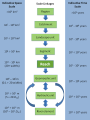
Figure 1. Hierarchy of spatial scales for the European Framework, including indicative spatial dimensions and timescales over which these units are likely to persist.

For detailed information on the hierarchical framework, please see the draft deliverable document File:HierarchicalFramework.pdf.
2. Delineation methodology.
For catchment assessment and management purposes, the aim should be to subdivide the entire catchment into a complete set of units at all spatial scales from catchment to reach. In large catchments, this may not be possible, but it is necessary to subdivide the catchment to the scale of its major landscape units, after which representative subcatchments within each landscape unit can be analysed, delineating segments and reaches along the main channel and major tributaries for detailed analysis.
For assessment of a particular reach or segment, a minimum assessment needs to focus on the specific reach or segment and larger spatial units that contain and are immediately upstream of the reach or segment under consideration

Figure 2: Delineation of spatial units
For detailed information on the delineation methodology, please see the draft deliverable document File:Delineation.pdf.
3. Characterisation methodology.
Characterisation of spatial units at the different scales attempts to draw together readily-available information, surveys, and data sets in ways that will promote understanding of the units and the linkages between them. Recommendations for characterisation take account of WFD requirements and make best use of existing pan-European and National data sets, including the outputs from physical habitat, riparian habitat, morphological, hydrological regime and fish continuity assessments, where they are available. Essential components of the characterisation are stressed
For detailed information on the characterisation methodology, please see the draft deliverable document File:Characterisation.pdf.
River Typology
Using information gained in the characterisation stage, river reaches are classified into one of 21 morphological types based on planform, morphological units, valley setting and channel bed sediment size.


Figure 3: Morphological typology or river reaches
For detailed information on the river typology, please see the draft deliverable document File:Typology.pdf.
4. Indicators
Key (primary) and secondary indicators are proposed at each spatial scale. Wherever possible, these are derived from information already assembled during characterisation. However, recommendations concerning new data collection and analyses are made where crucial information on these components is lacking. Indicators are used to support interpretation and process-based understanding of:
- Present condition of reaches and segments of river and floodplain
- Past condition of reaches and segments of river and floodplain
- Likely response of reaches and segments of river and floodplain to future scenarios.
For a preliminary outline of the indicators, please see the draft deliverable document File:Indicators.pdf.
Pages in category "River Characterisation"
The following 11 pages are in this category, out of 11 total.