File list
This special page shows all uploaded files.
| Name | Thumbnail | Size | User | Description | Versions | |
|---|---|---|---|---|---|---|
| 14:32, 7 August 2013 | RUHRSDORF ROSSATZ poster ruehrsdorf.pdf (file) | 3.09 MB | Saskia.deltares | Map of project site Ruhrsdorf-Rossatz | 1 | |
| 08:26, 7 August 2013 | Faltblatt LIFE-Projekt Nebenrinne Bislich-Vahnum.pdf (file) | 1.46 MB | Saskia.deltares | Brochure of the Bislich-Vahnum project (©NABU-Naturschutzstation e.V.) | 1 | |
| 08:24, 7 August 2013 | Map bislich.JPG (file) | 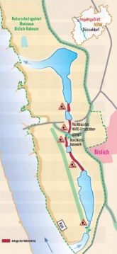 |
27 KB | Saskia.deltares | Map of planned measures in Bislich-Vahnum. Taken from NABU-Naturschutzstation e.V., Nebenstromrinne am Niederrhein | 1 |
| 21:49, 6 August 2013 | Amlach before after.JPG (file) | 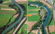 |
84 KB | Saskia.deltares | Amlach/St. Peter before and after construction of the measures. Taken from Life vein – Upper Drau River (2011) | 1 |
| 21:22, 6 August 2013 | Obergottesfeld before after.JPG (file) | 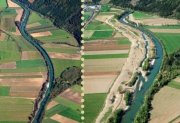 |
71 KB | Saskia.deltares | Obergottesfeld before and after the construction of the measures. Taken from Life vein – Upper Drau River (2011) | 1 |
| 20:59, 6 August 2013 | Rosenheim before after.JPG (file) | 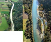 |
74 KB | Saskia.deltares | Rosenheim before and after the construction of the measures. Modified from Life vein – Upper Drau River (2011) | 1 |
| 19:29, 6 August 2013 | Map polder altenheim.JPG (file) |  |
27 KB | Saskia.deltares | Map of the project Polder Altenheim. Taken from Siepe, A. (2006) | 1 |
| 10:15, 2 August 2013 | Map Meinerswijk.JPG (file) |  |
47 KB | Saskia.deltares | Map of Meinerswijk project taken from Gebiedsvisie (see 2nd reference in reference list) | 1 |
| 11:52, 1 August 2013 | Map IJsseluiterwaarden Olst.JPG (file) | 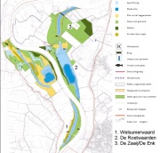 |
57 KB | Saskia.deltares | map of IJsseluiterwaarden Olst taken from the EIA (see source in reference list) | 1 |
| 11:22, 1 August 2013 | Vallei-van-de-grote-netekleur.png (file) |  |
252 KB | Saskia.deltares | Project area Grote Nete taken from www.sigmaplan.be | 1 |
| 12:50, 30 July 2013 | Skerne map.JPG (file) | 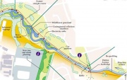 |
38 KB | Saskia.deltares | Map of measures Skerne | 1 |
| 12:31, 30 July 2013 | Cole measures.JPG (file) |  |
21 KB | Saskia.deltares | Map of the Cole project site | 1 |