Difference between revisions of "Ruhr Binnerfeld"
(→Measures selection) |
(→References) |
||
| Line 67: | Line 67: | ||
http://www.arnsberg.de/umwelt/wasser/renaturierung_binnerfeld.php | http://www.arnsberg.de/umwelt/wasser/renaturierung_binnerfeld.php | ||
| − | + | ||
Revision as of 14:53, 28 May 2014
Ruhr Binnerfeld
Key features of the case study
Site description
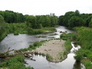
The restored site Binnerfeld in the river Ruhr is located in the Federal State of Northrhine-Westfalia in the urban area of the city Arnsberg. The Ruhr in Arnsberg belongs to the NATURA 2000 area, serves as an important place for local recreation and is highly frequented by cyclists, walkers and canoeists. Prior to restoration the river was flowing monotonously in a constrained and narrow planform fixed at the banks by riprap. The main aims of the restoration measures were to restore more natural hydromorphological conditions and to re-establish longitudinal connectivity resulting in a higher morphological and biologcial diversity. Moreover, it aimed to increase the aesthetic value of the river section and to raise people’s awareness of the importance of biodiversity by making nature tangible. Restoration measures were implemented step-by-step from 2007 to 2012 on a total river length of 3.5 km.
Measures selection
Restoration measures conducted:
- removal of bank fixation to initiate bankside erosion
- creation of flood-prone areas
- widening of river bed
- creation of side arms
- restructuring of river bed and banks by sediment addition
- placement of large wood
Success criteria
Ecological response
Hydromorphological response
Monitoring before and after implementation of the project
Socio-economic aspects
The area along the Ruhr serves as an important place for local recreation and is highly frequented by cyclists, walkers and canoeists. Furhtermore cafes and restaurant close to the restored site were built.
Contact person within the organization
Extra background information
References
http://www.arnsberg.de/umwelt/wasser/renaturierung_binnerfeld.php
Related Measures
- Add/feed sediment
- Widen water courses
- Allow/increase lateral channel migration or river mobility
- Shallow water courses
- Add sediments
- Initiate natural channel dynamics to promote natural regeneration
- Introduce large wood
- Remove bank fixation
- Recreate gravel bar and riffles
- Adjust land use to develop riparian vegetation
- Remove bank fixation
- Improve backwaters
- Lower river banks or floodplains to enlarge inundation and flooding
- Remove hard engineering structures that impede lateral connectivity
- Set back embankments, levees or dikes
- Retain floodwater
