DOÑANA/RESTAURACIÓN DEL ARROYO DEL PARTIDO
Doñana.El Partido
Key features of the case study
Arroyo del Partido collects water from a watershed of 308 km2 caracterized by a torrential behavior. Land use changes (and agricultural practices)and channelizations have induce problems of erosion, transport and deposition of sand.
Site description
Measures selection
Three alternatives could be considered:
- Keep the channel but modifying its design. The modification would consist in increase the hydraulic capacity of the channel (minimun flow channel and a high flow channel with lateral levees)to avoid erosion processes at the surroundings. The revegetation of the streambanks would serve to give stability against the erosion and improve the habitat conditions.
- Partial or total recovery of the original processes of El Partido at its final reach, allowing the expansion of the extraordinary flows over a wide floodplain, and restablishing the funtionality of the original braided channels. This would disipate energy and reduce the flow shear force. The sediments would be deposited at the floodplain before they arrive to the Doñana marshes.
- No action. Over the time, and after an initial period of sedimentation at the marshes, the artificial channel would disappear by aggradation and streambank erosion.At the end, the original floodplain would be recovered, and so the strem dynamics.
- Keep the channel but modifying its design. The modification would consist in increase the hydraulic capacity of the channel (minimun flow channel and a high flow channel with lateral levees)to avoid erosion processes at the surroundings. The revegetation of the streambanks would serve to give stability against the erosion and improve the habitat conditions.
Finally, the alternative 2 was selected because it achieves the technical and environmental objectives with an acceptable cost from the economic and social point of view.
Success criteria
Ecological response
Hydromorphological response
Monitoring before and after implementation of the project
The Doñana 2005 programme includes several studies to know the ecosystems´condition before, during and after the actions.Among the studies figure:
- Hydrogeomorphology
- Physical and chemical quality of water and fitozooplankton
- Aquatic and terrestial vegetal communities
- Estuary and freshwater macroinvertebrates
- Vertebrate communities
- Hydrogeomorphology
These studies started with the first project of the programme and lasted few years after the last one was finished.
Socio-economic aspects
The adopted solution has a moderate socio-economic importance, because it affects the posibility of use the land that will be included in the floodplain. In fact, this measure is not compatible with an intensive agricultural use, although it is possible to carry out an extensive livestock or forestry use.
Only the left margin of the stream will be part of the floodplain. In comparison with the intensive irrigated crops and inhabited areas of the right margin, the agricultural transformation is less developed. The right margin are still protected by the lateral levees and benefit from a lower flood risk derived from the restoration of the left floodplain.
Other positive socio-economic benefits of the environmental restoration is the potential for public use and environmental education at the area.
Contact person within the organization
Extra background information
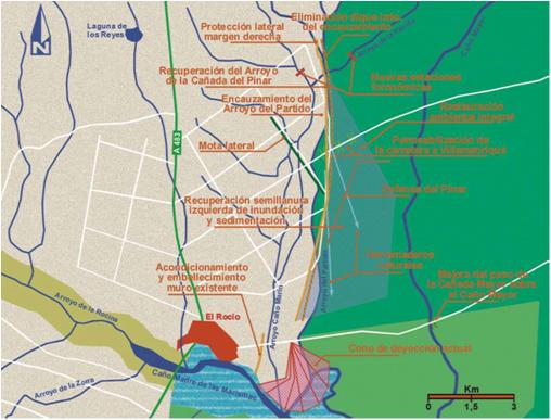
El Partido stream was channelized at its final reach for flood prevention. Removing the wall of the left margin, the expansion will allow the water to recover the original floodplain and restore the alluvial fan at its confluence with the marsh.
The wall of the right margin is maintained and reinforced to protect the strawberry fields and other irrigation farmland.
This action includes forestry and agri-environment measures, including restoration of the stream margins and actions in the alluvial fan to restore the natural appearance.

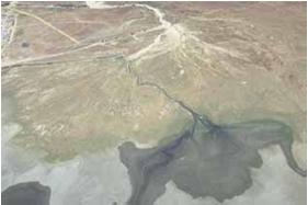
Aerial view of the alluvial fan previous to the restoration implementation

Map of the main measures
References
Related Measures
- Reduce undesired sediment input
- Reduce erosion
- Remove hard engineering structures that impede lateral connectivity
- Revegetate riparian zones