Difference between revisions of "Embankments, levees or dikes"
(→Effect/Impact on (including literature citations)) |
(→Effect/Impact on (including literature citations)) |
||
| Line 14: | Line 14: | ||
Bed incision associated with bank reinforcement and levee construction reduces connectivity between the river and its floodplain, but levee construction also directly reduces connectivity by increasing channel capacity (Gergel et al. 2002, Henry et al. 2002). The consequent loss of the floodplain as flood storage reduces downstream attenuation of flood peaks, potentially increasing flood risk. Such reductions in lateral connectivity not only damage functioning of the riparian zone but also reduce productivity, nutrient exchange, and dispersal of biota more widely across the | Bed incision associated with bank reinforcement and levee construction reduces connectivity between the river and its floodplain, but levee construction also directly reduces connectivity by increasing channel capacity (Gergel et al. 2002, Henry et al. 2002). The consequent loss of the floodplain as flood storage reduces downstream attenuation of flood peaks, potentially increasing flood risk. Such reductions in lateral connectivity not only damage functioning of the riparian zone but also reduce productivity, nutrient exchange, and dispersal of biota more widely across the | ||
floodplain (Jenkins and Boulton 2003). | floodplain (Jenkins and Boulton 2003). | ||
| + | |||
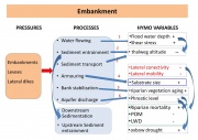
| + | [[File:Embankment.jpg|thumbnail|Conceptual framework of alteration of embankments, levees or dikes effects on HYMO processes and variables (POM=Particulate Organic Matter; LWD=Large Woody Debris).]] | ||
==Case studies where this pressure is present== | ==Case studies where this pressure is present== | ||
Latest revision as of 09:14, 1 September 2015
Contents
Embankments, levees or dikes
04. Morphological alterations
General description
Levees or dikes along a stream or river channel are longitudinal structures designed to prevent water passing from the river channel to the floodplain. Frequently river banks are reinforced and their level is raised by the construction of a bank top mound for flood control. Such bank stabilization eliminates river planform dynamics, and the addition of levees or dikes prevents lateral hydrological connectivity, which is crucial to hydromorphological complexity and the provision of diverse habitats, including refugee, for aquatic organisms.
Effect/Impact on (including literature citations)
Artificial bank protection affects channel morphology and dynamics by restricting the channel width and ability to migrate, by reducing energy consumption as a result of bank friction, by restricting bank sediment sources and thus sediment supply, and so enhancing erosion of the river bed (Winterbottom, 2000; Rinaldi, 2003). Extensive levee construction along both banks also contributes to greater stresses on the riverbed. High flows are associated with deeper water depth and higher flow velocities and hence, greater shear stresses on the river bed that lead to bed incision. Bed incision associated with bank reinforcement and levee construction reduces connectivity between the river and its floodplain, but levee construction also directly reduces connectivity by increasing channel capacity (Gergel et al. 2002, Henry et al. 2002). The consequent loss of the floodplain as flood storage reduces downstream attenuation of flood peaks, potentially increasing flood risk. Such reductions in lateral connectivity not only damage functioning of the riparian zone but also reduce productivity, nutrient exchange, and dispersal of biota more widely across the floodplain (Jenkins and Boulton 2003).
Case studies where this pressure is present
- Gameren
- Opijnen_-_Side_Channel
- Negro
- Manzanares
- Regelsbrunner_Aue
- DOÑANA/RESTAURACIÓN_DEL_ARROYO_DEL_PARTIDO
- Charlottenburg_artificial_bay
- Charlottenburg_wave-protected_shallow
- sheet_pile_protected_shallow_new
- sheet_pile_protected_shallow
- Westlicher_Abzugsgraben
- Vén_Duna_-_side_arm_reopening
- Renaturierung_Untere_Havel
- Tiétar._Proyecto_de_Permeabilización_Piscícola_del_Azud_de_Protección_del_Viaducto_de_la_Carretera_N-502_sobre_el_Río_Tiétar.
- Vallacuera_ravine._Removal_of_a_dyke.
- Millingerwaard
- Pisuerga._Improvement_of_ecological_state_of_the_river_between_the_dam_Pisuerga_Aguilar_de_Campo_and_Alar_del_Rey_(Palencia)_1st_Stage.
- Heessen_-_Optimisation_of_the_pSCI_“Lippe_floodplain_between_Hamm_and_Hangfort”_(LIFE05/NAT/D/000057)
- Ahlen-Dolberg_-_Optimisation_of_the_pSCI_“Lippe_floodplain_between_Hamm_and_Hangfort”_(LIFE05/NAT/D/000057)
- Aaijen_-_Removal_of_Bank_Fixation
- Klebach_-_Side_channel
- Olivenza._Hydrological_and_Forestry_Restoration_of_the_Olivenza_riverside,_2ª_phase
- Tordera_-_Restoration_of_a_secondary_channel_of_the_Tordera_River
- Odra._Actions_for_environmental_restoration_and_flood_control_in_the_lower_basin_of_the_Odra_River_(Burgos)
- Bakenhof_-_Dyke_relocation
- Soest_-_Optimisation_of_the_pSCI_“Lippe_floodplain_between_Hamm_and_Hangfort”_(LIFE05/NAT/D/000057)
- Lek_bij_Everdingen_-_Groyne_Shields
- Bouxweerd
- Bergen_-_Removal_of_Bank_Fixation
- River_Quaggy,_Chinbrook_Meadows
- River_Ravensbourne_at_Cornmill_Gardens
- Pastures_Bridge_Rehabilitation
- Inchewan_Burn_Bed_Restoration
- River_Roding_at_Ray_Lodge_Park
- River_Brent_at_Tokyngton_Park
- River_Wensum_Rehabilitation_Project
- River_Skerne_EU-LIFE_project
- Sella
- Oberwerries_-_Optimisation_of_the_pSCI_“Lippe_floodplain_between_Hamm_and_Hangfort”_(LIFE05/NAT/D/000057)
- Piles_-_Creation_a_wetland
- Asseltse_Plassen_-_Bank_erosion
- Beneden-Leeuwen_-_Side_channel
- Vreugderijkerwaard_-_Side_channel
- Chícamo_Life_project._Conservation_of_Aphanius_iberus´_genetics_stocks_(_Murcia_).
- Uilenkamp
- Rijkelse_Beemden_-_River_bed_widening
- Tajo._Improvement_of_ecological_state_of_the_Tajo_and_tributaries__riverside_affected_by_the_spill_of_kaolin,_at_Poveda_de_la_Sierra_and_Taravilla_(Guadalajara)
- Low_reach_of_River_Cinca
- IJssel
- River_Rhine_-_IJsseluiterwaarden_Olst
- Scheldt_-_Vallei_Grote_Nete
- Rhine_-_Meinerswijk
- Hampshire_Avon_-_Hale
- Rhine_-_Polder_Altenheim
- Restoration_and_remeandering_of_the_Müggelspree_-_downstream_Mönchwinkel
- Drava_-_River_Widening_Amlach/St._Peter
- Drava_-_River_Widening_Obergottesfeld
- Drava_-_River_Widening_Rosenheim
- Rhine_-_Nebenrinne_Bislich-Vahnum_(LIFE08_NAT/D/000007)
- Meuse_-_Overdiepse_Polder
- Rhine_-_Ontpoldering_Noordwaard
- Donau_-_Rührsdorf-Rossatz_(LIFE03_NAT/A/000009)
- Donau_-_Aggsbach_(LIFE03_NAT/A/000009)
- Rhine_-_Emmericher_Ward_(LIFE10_NAT/DE/000010)
- Regge_Velderberg
- Narew_river_restoration_project_
- Lower_Traun
- Middle_Warta_River_Valley
- Ruhr_Binnerfeld
- Drava_-_Kleblach
- Thur_
- Töss
- Enns_-_Aich
- Vääräjoki_-_Niskakoski
- KUIVAJOKI
Possible restoration, rehabilitation and mitigation measures
- Remove barrier
- Widen water courses
- Allow/increase lateral channel migration or river mobility
- Remove bank fixation
- Remove or modify in-channel hydraulic structures
- Remove bank fixation
- Lower river banks or floodplains to enlarge inundation and flooding
- Set back embankments, levees or dikes
- Reconnect backwaters and wetlands
- Remove hard engineering structures that impede lateral connectivity
- Restore wetlands
- Construct semi-natural/articificial wetlands or aquatic habitats
- Isolation of water bodies
